Routine private helicopter commuting to/from Tysons is not conceptually prohibited by federal aviation rules (a helicopter can legally operate and even fly lower than fixed‑wing minimums if conducted without hazard), but it is practically constrained by (i) the availability and legality of landing sites near Tysons (zoning + fire code + state landing‑area licensing/registration + FAA airspace/Part 157 notice), (ii) the Washington, D.C. SFRA/FRZ security and procedural environment affecting much of the region’s airspace, and (iii) predictable community pushback (noise, safety perception, equity, and environmental concerns). [1]
A key feasibility boundary is that Tysons is inside the National Capital Region operating envelope where the FAA recommends/mandates specific training and procedures for pilots operating within a large radius of the DCA VOR/DME (SFRA training is mandatory within 60 NM per FAA safety material) and where some helicopter activity over the District has been restricted post‑9/11. [2]
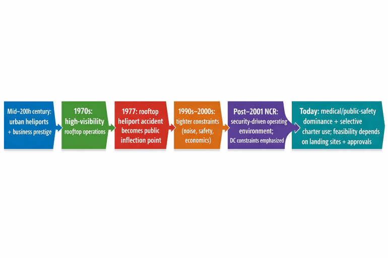
Historic precedent matters: the “heyday” of urban heliports and rooftop access is real (e.g., scheduled passenger service from the Pan Am Building rooftop heliport in New York), but public tolerance and policy shifted after safety incidents and other externalities; the 1977 Pan Am Building rooftop heliport accident is a frequently cited inflection point in the public narrative of rooftop helicopter operations. [3]
On the economics, the “GDP gap” needs to be decomposed into two different “gaps”:
- Real vs nominal (current‑dollar) distinction: nominal outcomes include price and spending effects (aviation service revenues, higher housing/office rents), while real outcomes require additional quantities (more labor hours, higher productivity, more output). BEA’s county GDP program publishes real GDP measures and also reports other aggregates in current dollars, underscoring that these are distinct accounting lenses. [4]
- Output gap framing: the relevant macro capacity question is whether helicopter commuting increases actual real output (Y) and/or the economy’s potential real output (Y*) by relaxing time/space constraints on labor and the allocation of high‑value activities.
Because a full county‑GDP quantification requires extracting Fairfax County and multi‑county regional series from BEA interactive tables/downloads, the report below provides (i) a finance-grade valuation model in terms of hours saved and monetized benefits, (ii) scenario NPVs under explicit assumptions, and (iii) a data appendix showing the authoritative BEA entry point and how to obtain the county figures and industry breakdowns needed to translate the time‑savings results into real‑GDP levels and sector value‑added. [5]
Definitions and accounting framework
This section defines the variables used in the requested “Y‑GDP vs N‑GDP” framing and separates real (quantity) effects from current‑dollar (price × quantity) effects.
Nominal GDP (NGDP, “current-dollar GDP”) is the value of final goods and services produced, measured at current prices. Nominal GDP moves because of both quantities produced and prices paid.
Real GDP (Y, “inflation-adjusted GDP”) attempts to isolate changes in quantities produced by removing price changes (conceptually holding prices constant or using chain-weighting). BEA’s county GDP program explicitly reports “real GDP” changes across counties, illustrating that the program is designed to separate real (quantity) shifts from current-dollar movements. [4]
Potential GDP (Y*) is the level of real output consistent with the economy operating at sustainable capacity (labor, capital, and productivity), without overheating inflationary pressure. In this project’s context, the mechanism for raising Y* would not be “helicopters per se,” but higher effective labor supply / matching (more high-skill hours available in the Tysons labor market) and/or durable productivity effects from improved accessibility for high‑value work.
Output gap is typically expressed as:

A positive gap implies output above sustainable capacity; a negative gap implies slack.
“Y‑GDP vs N‑GDP gap” (interpreting your phrasing) can be operationalized two ways: – Price wedge lens: NGDP growth minus real GDP growth is, in effect, related to economy‑wide price inflation/deflators; in a localized project, “nominal uplift” can be large even when “real uplift” is modest if the policy mainly increases prices/rents/fees rather than quantities. – Welfare vs production lens: time savings can generate consumer surplus (people value time) even if measured real GDP changes are smaller, because GDP accounting only counts market production—not all welfare gains.
For any policy case involving commute-mode substitution, the “translation” from time savings to GDP differs by channel:
- Nominal channels (current dollars): charter fees, fueling, maintenance, pilot wages, landing/handling fees, insurance premiums, and induced spending in Tysons (restaurants, services) all raise measured nominal transactions if paid in the market.
- Real channels: real GDP rises only to the extent time savings and reliability improvements are converted into additional market output (more billable hours, more deals closed, more production) or unlock new investment and durable capacity (e.g., new office nodes enabled by faster commutes).
DOT’s Value of Travel Time guidance exists precisely because time savings are a central category in transportation appraisal; DOT notes that valuing travel time is “critical” for evaluating transportation investments and rulemakings, and that guidance is designed for consistent benefit evaluation. [6]
Historical narrative of business helicopter commuting
Urban helicopter commuting has repeatedly cycled through three eras: expansion, constraint, and reinvention. Two primary-source narratives anchor this pattern: (i) the high-visibility rooftop heliport environment (New York), and (ii) the security-dominated airspace environment of the National Capital Region.
The rooftop-heliport era and the “heyday” image. By the 1970s, high-profile rooftop heliports supported scheduled service and elite business travel in dense CBDs. The Pan Am Building rooftop heliport in Manhattan is emblematic: on May 16, 1977 a Sikorsky S‑61L helicopter operated by New York Airways was parked with rotors turning on the rooftop heliport while passengers were boarding for a scheduled flight to JFK, when a landing gear failure led to a rollover and multiple fatalities (including people waiting to board and a pedestrian below struck by a rotor blade segment). [3]
Inflection from safety perception and operational risk. The 1977 event is not merely a mechanical failure story; it illustrates why rooftop operations carry unique externalities: even an on-pad failure can propagate risk beyond the pad (pedestrians below). The NTSB’s accident report describes fatalities and the causal chain (fatigue failure of a landing gear fitting leading to collapse with rotors turning). [3]
Reinvention under security constraints in the Washington region. In Metropolitan Washington, the MWCOG regional helicopter planning work emphasizes that, post‑9/11, “almost all corporate, electronic news, aerial filming, and utility helicopter activity” was restricted from operating in the District of Columbia and from using Reagan National Airport; the report further states that current civilian helicopter activity over the District (including police and EMS) requires prior permission from the FAA and security agencies. [7]
Why “the market” is hard to size. MWCOG also highlights a persistent measurement limitation: “There is no single source of data for based helicopters or helicopter operations,” and at towered airports helicopter operations may be recorded in ways that do not isolate helicopter activity distinctly, complicating demand baselining. [7]
Regulatory feasibility in the Tysons and DMV environment
This section provides the requested jurisdiction-by-jurisdiction matrix and answers the “movie-style rooftop landing” question as of the current research date.
Legal matrix for establishing routine commuting service
| Jurisdiction / regime | What it governs for this use case | Practical implication for routine Tysons commuting | Primary-source pointer |
| Federal operational rules (minimum safe altitudes; helicopters) | Baseline flight rules and minimums; helicopters have flexibility but must operate without hazard and comply with Administrator-prescribed helicopter routes/altitudes where applicable | Flying low over congested areas is constrained; helicopters may operate below fixed-wing minimums only if “without hazard,” and may be required to follow prescribed routes/altitudes | FAA “Guide to Low Flying Aircraft” quoting 14 CFR 91.119, including helicopter-specific clause [8] |
| Federal facility notice / airspace evaluation (Part 157) | Establishes notice requirements for proposals to construct/alter/deactivate civil airports and includes heliport submittal process; FAA evaluates airspace and ground safety impacts | Any new Tysons-area heliport/helistop intended for routine use should expect a Part 157 notice and FAA airspace/ground-safety evaluation as part of the development critical path | FAA Part 157 page describing purpose and evaluation basis [9] |
| National Capital Region airspace procedures (SFRA/FRZ) | Procedural/security requirements for operations within defined radii of DCA VOR/DME | SFRA training is stated as mandatory within 60 NM of DCA VOR/DME; radios, transponder, and specific flight plans are required—raising compliance burden and reducing “frictionless” commuting | FAA DC SFRA safety alert (mandatory training within 60 NM; flight plan requirements) [10] |
| Commonwealth-level landing-area licensing and registration | State-level rules for establishing private landing areas (including heliports/helipads) relative to public-use airports; requires zoning documentation | A Tysons-area private-use helipad/heliport is not just a federal question; Virginia requires registration or a private-use landing area license depending on proximity to licensed public-use airports, and requires written documentation of zoning/special use compliance | Virginia Admin Code 24VAC5-20-170 [11] |
| Local zoning authority and constraints on bans | Localities cannot impose a total ban on non-commercial personal helicopter departures/landings, but may require special exceptions/permits for repetitive operations and impose reasonable conditions | Routine commuting implies repetitive operations; therefore expect special use/special exception permitting and conditions (hours, approach paths, noise constraints) even if a use is not banned outright | VA Code § 15.2‑2293.2 [12] |
| Local application of zoning to airspace | Zoning ordinances apply to superjacent airspace above land areas | Rooftop pads and approach/departure paths intersect local zoning authority; development approvals are likely to scrutinize airspace impacts as well as ground impacts | VA Code § 15.2‑2293 [13] |
| Fire prevention code requirements for helistops/heliports in Virginia | Life-safety requirements for helistops/heliports, including rooftop facilities (maintenance, exits, standpipes, foam where required) | Rooftop helistops are a building-and-fire-code project as much as an aviation project; life safety systems (e.g., standpipe systems) become part of feasibility/cost | Virginia Statewide Fire Prevention Code amendments addressing helistops/heliports and rooftop systems [14] |
| District-specific fire code supplement | Special-occupancy / maintenance requirements including helistops and heliports in D.C. | For “DMV” solutions involving D.C. landing sites, fire code compliance is a separate gating item from FAA procedures | DC fire code supplement scope includes helistops/heliports [15] |
| Fairfax County zoning process (Tysons planned district context) | Tysons is governed under planned development district regulations that explicitly include “special exception uses” and references to special permit pathways | A Tysons landing facility proposal should assume a discretionary approval process (special permit/special exception), fastened to performance standards and compatibility criteria | Fairfax County zoning ordinance Article 6 structure (special permit/special exception pathways) [16] |
Can a private helicopter legally land on top of “any building” in Tysons or the broader DMV?
As a matter of routine, planned operations, “landing on any building” is generally not lawful or not practically approvable absent a designated, permitted, and code-compliant facility. The gating reasons are cumulative:
- Property permission and safety: helicopter operations below typical minimums must be conducted “without hazard,” and landing/takeoff operations that create surface hazard violate the spirit and letter of minimum safe altitude rules. [8]
- Facility establishment pathway: creating or materially changing a heliport/helistop for routine use is expected to trigger FAA notice/airspace evaluation pathways (Part 157) and state/local licensing/registration requirements. [17]
- Local zoning: even where outright bans are constrained by Virginia law for non-commercial personal helicopter use, local zoning may require discretionary permits for repetitive landings and can impose conditions. [12]
- Building/fire code: rooftop helistops/heliports bring exits, standpipe, and (where required) foam protection considerations that are part of ongoing facility maintenance and inspection reality. [18]
In contrast, emergency landings (e.g., to protect life or respond to a true emergency) are a distinct category and are not the same as routine commuting; this report evaluates the routine commuting case, which is inherently repetitive and therefore falls directly into the special permit/special exception logic. [12]
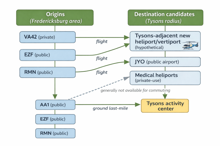
Current infrastructure options from the Fredericksburg area and candidate destinations near Tysons
Because routine commuting is ultimately a “where can you land?” problem, this section inventories practical origin points in the Fredericksburg area and identifies candidate destinations within a plausible radius of Tysons—flagging whether they are actually usable for private commuting.
For geographic calculations, Tysons is represented by the census-designated place coordinate listed publicly (38°55′7″N, 77°13′47″W). [19]
Facility inventory table with distances and estimated last-mile travel
Assumptions for the table below: – Distances are great-circle distances computed from published coordinates. – “Last-mile time” is an estimate based on great-circle distance × 1.3 (road factor) and assumed average road speed (35 mph for airport-to-Tysons trips; 25 mph for shorter urban trips). These are planning heuristics, not measured travel times.
| Facility | Role | Facility type / access | Published lat/long basis | Distance to Tysons (mi, great-circle) | Indicative last-mile to Tysons (min, estimate) | Notes on commuting usability |
| Dogwood Airpark (VA42) | Origin | Airport, private use (permission required) | FAA-info summary as republished by AirNav (effective Feb 2026) [20] | 40.4 | — | Feasible origin only with permission; supports charter/rental concept if operator secures access [20] |
| Shannon Airport (EZF) | Origin | Airport, public use | AirNav FAA-info summary (effective Feb 2026) [21] | 46.5 | — | Public-use origin with fixed facilities; common charter base concept [21] |
| Stafford Regional Airport (RMN) | Origin | Airport, public use | AirNav FAA-info summary (effective Jul 2025) [22] | 37.9 | — | Public-use origin; closer air distance to Tysons among listed Fredericksburg-area choices [22] |
| Leesburg Executive Airport (JYO) | Destination candidate | Airport, public use | AirNav FAA-info summary (effective Mar 2026) [23] | 20.8 | 46.3 | Public-use airport that can accept helicopters; last-mile to Tysons may be material, reducing time-savings vs a Tysons-adjacent pad [23] |
| Inova Fairfax Hospital Heliport (72VA) | Destination candidate | Heliport, private medical use | AirNav FAA-info summary (effective Feb 2026) [24] | 4.3 | 13.3 | Very close to Tysons, but “private use, medical use” indicates not a commuting option absent owner/operator authorization and mission compatibility [24] |
| Inova Fair Oaks Hospital Heliport (74VA) | Destination candidate | Heliport, private medical use | AirNav FAA-info summary (effective Jul 2025) [25] | 8.4 | 26.1 | Close but medical/private; likewise not a routine commuter option [25] |
A key takeaway is that the closest pads near Tysons tend to be mission-restricted (medical/hospital), while the usable public airports may impose a meaningfully longer last-mile—pushing the economics toward either (i) a purpose-built Tysons-area landing facility or (ii) acceptance of a longer ground leg that dilutes the “helicopter commute” advantage.
Economic framework, valuation model, and scenario NPVs
Valuing time savings and converting to economic impacts
DOT emphasizes that valuing travel time is central to transportation benefit appraisal and that values should be grounded in consistent guidance (including sensitivity ranges). [6]
For helicopter commuting, time savings create economic value in two distinct ways:
- Welfare / willingness-to-pay for time: the commuter values reduced time, greater comfort, and privacy. This is a standard DOT-style benefit category. [6]
- Production / real output: if some of the saved time is converted into additional work output (billable hours, client work, transaction execution), real GDP can rise; if the improved accessibility also attracts additional high-productivity workers or firms, potential GDP (Y*) can rise through labor-supply and productivity channels.
Because the proportion of time savings that converts into additional market output is highly user-specific (especially in UHNW/HNW routines), the model below separates: – Monetized time savings (benefit proxy), directly aligned with DOT benefit-cost framing, [6]
from
– GDP translation, which is scenario- and behavior-dependent.
Scenario set and base-case assumptions
Three scenarios are modeled:
- Scenario A (status quo): no routine helicopter commuting; travel occurs by road.
- Scenario B (expanded via existing facilities): routine commuting feasible only using current airports/landing facilities with significant last-mile legs (illustratively, parity with a “public airport + car” construct).
- Scenario C (expanded with Tysons-adjacent landing): a new private-use landing facility near Tysons (ground-level or rooftop) with short last-mile.
Base-case numeric assumptions used (explicitly “illustrative”): – Peak-ish road roundtrip: 4.0 hours/day (reflecting the area’s widely noted congestion conditions). [19]
– Helicopter-enabled time saved: – Scenario B: 1.33 hours/day (road-to-air substitution partially diluted by last-mile). – Scenario C: 2.12 hours/day (Tysons-adjacent landing reduces last-mile). – Workdays: 230/year. – Value of time (VOT): $200/hour baseline for monetization, with sensitivity shown (DOT guidance supports income-based valuation and sensitivity ranges). [6]
– Discount rate: 8%, horizon: 20 years. – Incremental infrastructure costs (illustrative, to be replaced with engineering estimates): – Scenario B enabling costs (ground ops, staging, etc.): capex $2M, opex $0.5M/yr. – Scenario C: capex $20M, opex $2M/yr.
Modeled results
Under the base case, annual time saved per daily roundtrip commuter is:
- Scenario B: 1.33 hours/day × 230 = ~306 hours/year
- Scenario C: 2.12 hours/day × 230 = ~488 hours/year
At $200/hr, that equals ~$61k/year (Scenario B) versus ~$98k/year (Scenario C) monetized time value per commuter.
NPV table (monetized time value benefits vs. enabling costs)
| Daily commuters (round-trip) | NPV Scenario B enabling ($M) | NPV Scenario C new Tysons-adjacent facility ($M) | Incremental NPV of Scenario C vs B ($M) |
| 25 | 8.1 | -15.7 | -23.8 |
| 100 | 53.2 | 56.1 | 3.0 |
| 250 | 143.3 | 199.7 | 56.5 |
Interpretation: – Under these assumptions, a new Tysons-adjacent facility becomes attractive only once daily commuter volumes are large enough that time-value benefits dominate capex/opex. – The “upgrade” decision (Scenario C vs B) breaks even at a meaningfully higher commuter count than “new vs drive,” because Scenario B already captures some time savings.
Break-even sensitivity (new facility vs drive)
Break-even daily commuters for Scenario C depends strongly on VOT and time saved (both are the key value drivers in UHNW/HNW commuting):
| VOT ($/hr) | Time saved (hrs/day, round-trip) | Break-even daily commuters (new facility vs drive) |
| 100 | 1.50 | 117 |
| 100 | 2.12 | 83 |
| 100 | 2.50 | 70 |
| 200 | 1.50 | 59 |
| 200 | 2.12 | 41 |
| 200 | 2.50 | 35 |
| 400 | 1.50 | 29 |
| 400 | 2.12 | 21 |
| 400 | 2.50 | 18 |
These ranges match DOT’s emphasis that travel time valuation is highly material in benefit-cost analysis. [6]
Translating the model into real GDP (Y), nominal GDP (NGDP), and potential GDP (Y*)
Nominal GDP (current-dollar) channels likely scale with: – Direct aviation service spend: charter flights, maintenance, fuel, FBO/handling, insurance, landing fees (market transactions). – Capital formation: construction/retrofit spending for landing facilities (investment). – Secondary spending: increased demand for premium housing and professional services near Tysons.
Real GDP (Y) and potential GDP (Y*) channels require additional assumptions about behavior and capacity: – Y impact (near-term): depends on whether the regional economy is demand-constrained or supply-constrained and whether time savings convert into additional market output (rather than leisure). – Y* impact (structural): requires evidence that improved accessibility changes the long-run equilibrium of where high-productivity labor is supplied and where firms invest.
A practical way to keep this finance-grade and measurable is to treat time saved as an input into a “convert-to-output” function:

The share converted to work and the value added per hour should be estimated from client-specific data (e.g., billing rates, compensation, profit contribution) and anchored in BEA county GDP-by-industry and employment totals for Fairfax County and the DC metro area once extracted from BEA’s county GDP datasets. [4]
Sector impacts, stakeholder pushbacks, and mitigation design
Likely sector winners and losers
Because helicopter commuting is high-cost and narrow-market, impacts concentrate in a small set of sectors; the main macro question is whether it helps retain/attract enough high-value activity to have second-order spillovers.
| Sector | Direction of impact | Mechanism | Magnitude driver |
| Aviation services (charter, maintenance, ground handling, pilot labor) | Positive | New demand for flight hours, maintenance cycles, hangar/FBO services | Daily commuter count; charter pricing; aircraft utilization |
| Premium real estate (Tysons office/residential) | Positive (localized) | Accessibility premium and willingness to pay for proximity/privacy | Whether commuting unlocks high-wage relocations and office leasing |
| Road transport (some portion of peak congestion externalities) | Mixed/slightly negative for certain services | Mode substitution reduces some trips; but effect is small unless volumes scale dramatically | Number of displaced peak car trips |
| Professional services (legal, finance, consulting) | Potentially positive | More “effective hours” and more high-value client interactions | Conversion of saved time into billable/market output |
| Public sector (planning, enforcement, emergency services) | Mixed | Additional oversight; potential need for noise enforcement and safety planning | Operating hours, flight paths, noise complaints |
Anticipated pushbacks around Tysons and the DMV
Noise and community acceptance. Even when helicopters can legally operate below fixed-wing minimum altitudes, they must do so “without hazard,” and the public commonly perceives low-flying helicopters as intrusive; this becomes a political economy constraint, not merely an aviation one. [8]
Safety perception (especially rooftop/community exposure). The rooftop-heliport narrative is shaped by the visibility of high-profile events; the NTSB’s Pan Am Building accident illustrates how an on-pad failure can have off-pad consequences. [3]
Security and airspace complexity. In the National Capital Region, helicopter operations intersect a security-intensive airspace environment; MWCOG describes restrictions on certain civilian helicopter activities and a requirement for prior permissions over the District. [7]
Equity concerns. A routine helicopter commute is, by definition, a premium product for UHNW/HNW users; the policy argument will likely be challenged if public resources or regulatory flexibility appear to subsidize private convenience.
Environment. While not quantified here, helicopter operations raise issues of emissions and local air quality, and—more salient in dense areas—noise externalities.
Mitigation and design strategies aligned to the regulatory landscape
Mitigations must be designed so they map to actual enforceable levers:
- Noise abatement + operational envelopes: limit operating hours; define approach/departure corridors; enforce minimum helicopter routes/altitudes where prescribed by the Administrator. [8]
- “Community benefit” packaging: if a Tysons landing facility is pursued, tie approval to measurable community protections (limited slots, restricted days, safety and complaint response protocols), consistent with Virginia’s allowance for “reasonable conditions” on special permits for repetitive landings. [12]
- Facility design for life safety: rooftop facilities must incorporate exits/standpipes and, where required, foam capability; these requirements become part of the engineering and operating cost baseline. [18]
- SFRA procedural compliance program: build pilot/operator SOPs around SFRA training, flight plan requirements, and avionics to reduce violation risk in the DC environment. [10]
- Permitting pathway discipline: treat the project as a multi-regulator transaction: FAA notice/evaluation (Part 157), state registration/licensing (24VAC), local zoning/special exceptions, and fire/building inspection. [26]
Regulatory conclusion, appendices, and next research tasks
Feasibility conclusion
Actions plausibly doable under current law (subject to approvals): – Operate routine helicopter flights outside the District under standard federal rules, provided operations are conducted without hazard and comply with any prescribed helicopter routes/altitudes. [8]
– Establish a Virginia private-use landing area (including a helipad/heliport) through the state’s registration/licensing pathway and with local zoning documentation, with recognition that repetitive operations may require special exceptions/permits and conditions. [27]
– Build or retrofit a rooftop or ground facility only if building/fire code requirements for helistops/heliports are met and maintained. [14]
– Operate within the NCR environment with SFRA procedural compliance (training, flight plan, avionics). [10]
Actions likely requiring higher-level policy/security change (not just local permitting): – Restoring broad public/commercial access to certain D.C.-core heliport concepts is tightly bound to security policies; MWCOG describes ongoing restrictions and permission requirements for civilian helicopter activity over the District. [7]
Regulatory appendix (primary-source anchors)
- FAA minimum safe altitudes and helicopter exception (14 CFR 91.119 quoted in FAA guidance): helicopters may operate below fixed-wing minimums only if conducted “without hazard,” and must comply with any specifically prescribed routes/altitudes. [8]
- FAA Part 157 notice and evaluation purpose: the FAA uses notice to evaluate safe/efficient airspace use and safety of persons and property on the ground for proposed airport/heliport actions. [9]
- FAA DC SFRA training and flight plan requirements: SFRA training described as mandatory within 60 NM of DCA VOR/DME; requirements include radio, transponder, and appropriate flight plans. [10]
- Virginia regulation of helicopter use under local zoning: no total ban for non-commercial personal helicopter operations; localities may require special exceptions/permits for repetitive landings and impose reasonable conditions. [12]
- Virginia private landing area registration/licensing: registration if >5 NM from licensed public-use airport; license needed within 5 NM; requires zoning documentation; hospitals may restrict public use to hospital-related use only. [11]
- Virginia fire prevention code provisions for helistops/heliports: includes maintenance requirements and systems (exits/standpipes/foam protection where required) for rooftop helistops/heliports. [14]
- D.C. fire code supplement scope includes helistops/heliports. [15]
- Fairfax County planned development district framework (Tysons context) includes special permit and special exception structures relevant to discretionary approvals. [28]
Data appendix (sources and what to extract next)
- BEA GDP by County program entry point: use the BEA “GDP by County” page to access the 2024 release, downloadable data, and methodology documents. This is the authoritative starting point for Fairfax County real GDP levels and industry mixes needed for the “Y, NGDP, Y*” translation. [4]
- DOT value of travel time guidance: DOT provides the policy basis for valuing time savings and for sensitivity analyses; extract the numeric VOT parameters from DOT’s published PDFs appropriate to your analysis year and user category. [6]
- FAA/MWCOG helicopter activity and constraints: MWCOG’s regional helicopter plan summary describes DC restrictions and highlights the lack of clean operational data series, guiding what to collect from operators and ATC logs. [7]
- Facility data (FAA-derived summaries) for origin/destination pads and airports can be pulled from facility records; AirNav republishes FAA information effective on specific cycles and is useful for coordinates and access classification. [29]
Risk register with fatal-flaw tests
| Risk | Why it matters | Fatal-flaw test (go/no-go) | Mitigation workstream |
| No approvable Tysons-adjacent landing site | Without a landing site, “routine commuting” collapses to “airport + car,” shrinking value proposition | Identify at least one parcel/building that can satisfy zoning + state landing-area requirements + fire code + FAA evaluation | Site screening + pre-application meetings; Part 157 pathway planning [26] |
| Community rejection (noise/safety politics) | Even legal projects fail if politically infeasible | If predicted complaint burden exceeds tolerable thresholds or elected officials oppose, approvals stall | Noise abatement design + hours limits + condition packages [30] |
| NCR procedural/security noncompliance | Violations in SFRA/FRZ environments carry severe operational risk | Demonstrate operator capability: trained pilots, SOPs, avionics, dispatch compliance | SFRA compliance program; contracted operator due diligence [2] |
| Economics insufficient at realistic commuter counts | If daily users are too few, new infrastructure NPV can be negative | Use break-even table: if expected steady-state users < ~90 (upgrade case, base assumptions), new facility is hard to justify | Build from Scenario B first; secure anchor tenants; phased capex |
| Liability/insurance escalation | Insurance costs can dominate small-volume operations | Obtain quotes and bindable terms consistent with operating model | Insurance market scan; safety management system; facility standards [14] |
Recommended next-step research tasks
- Extract Fairfax County (and neighbor counties) real GDP and current-dollar GDP levels and industry composition from BEA’s county GDP downloadable data and interactive tables, then compute GDP-per-worker and GDP-per-hour proxies to translate the time-savings model into Y and Y* deltas. [4]
- Identify candidate Tysons parcels/buildings and run a structured permitting feasibility screen: Virginia private landing area licensing/registration triggers, Fairfax special exception likelihood, and rooftop fire code compliance requirements (standpipes/foam/exits). [31]
- Obtain operator-level data (Part 135 charter availability, pricing, aircraft types, dispatch constraints) and build a demand curve for UHNW/HNW commuters; MWCOG’s observation about limited standardized helicopter ops data suggests primary data collection is essential. [7]
- Build a noise and corridor concept of operations aligned to the FAA helicopter routing authority and SFRA procedures, then test stakeholder acceptance in a structured engagement process. [32]
[1] [8] [32] https://www.faa.gov/media/29701
https://www.faa.gov/media/29701
[2] [10] https://www.faa.gov/air_traffic/flight_info/aeronav/safety_alerts/media/CS_21-04_SA_Washington_DC_SFRA.pdf
[3] https://www.ntsb.gov/investigations/AccidentReports/Reports/AAR7709.pdf
[4] [5] https://www.bea.gov/data/gdp/gdp-by-county
https://www.bea.gov/data/gdp/gdp-by-county
[6] https://www.transportation.gov/office-policy/transportation-policy/revised-departmental-guidance-valuation-travel-time-economic
[7] https://www.mwcog.org/file.aspx?A=O2Xdu2L2rYRJDGYtasXaw2mti44UX0FwsxCQ%2B56JHac%3D&D=YoiJa%2F1MDsKW%2Brq8f0yXL4HpvHGUxhRdb67g9dXsDrw%3D
[9] [17] [26] https://www.faa.gov/airports/central/engineering/part157
https://www.faa.gov/airports/central/engineering/part157
[11] [27] [31] https://law.lis.virginia.gov/admincode/title24/agency5/chapter20/section170/
https://law.lis.virginia.gov/admincode/title24/agency5/chapter20/section170/
[12] [30] https://law.lis.virginia.gov/vacode/title15.2/chapter22/section15.2-2293.2/
https://law.lis.virginia.gov/vacode/title15.2/chapter22/section15.2-2293.2/
[13] https://law.lis.virginia.gov/vacode/title15.2/chapter22/section15.2-2293/
https://law.lis.virginia.gov/vacode/title15.2/chapter22/section15.2-2293/
[14] [18] https://www.dhcd.virginia.gov/sites/default/files/DocX/building-codes-regulations/archive-codes/2021/2021-virginia-statewide-fire-prevention-code.pdf
[15] https://os.dc.gov/sites/default/files/dc/sites/os/publication/attachments/OS_DCMR_12H_Fire_Code_Supplement.pdf
[16] [28] https://www.fairfaxcounty.gov/tysons/sites/tysons/files/assets/documents/pdf/zoning/art06.pdf
[19] https://en.wikipedia.org/wiki/Tysons%2C_Virginia
https://en.wikipedia.org/wiki/Tysons%2C_Virginia
[20] [29] https://www.airnav.com/airport/va42
https://www.airnav.com/airport/va42
[21] https://www.airnav.com/airport/EZF/
https://www.airnav.com/airport/EZF/
[22] https://www.airnav.com/airport/RMN
https://www.airnav.com/airport/RMN
[23] https://www.airnav.com/airport/JYO
https://www.airnav.com/airport/JYO
[24] https://www.airnav.com/airport/72VA
https://www.airnav.com/airport/72VA
